Castles of "Syria" CHASTEL BLANC vs CHASTEL ROUGE

CHASTEL BLANC
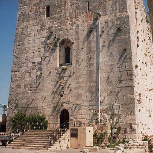
Chastel Blanc (Arabic: برج صافيتا, Burj Safita or Safita Tower) is a medieval structure in Safita, western Syria. It was built by the Knights Templar during the Crusades upon prior fortifications. Located on the middle hill of Safita's three hills, it offers a commanding view of the surrounding countryside, and was a major part of the network of Crusader fortifications in the area. From the roof, a view ranging see from the Mediterranean Sea to the snow-covered mountains of Lebanon, and County of Tripoli, is offered. From Chastel Blanc it would have been possible to see the Templar strongholds at Tartus and Ruad Island to the northwest, Chastel Rouge on the coastline to the southwest, Akkar to the south, and Krak des Chevaliers (the headquarters of the Syrian Knights Hospitallers) to the southeast. The tower served both as a chapel and a fortress, with 3 metres (9.8 ft) thick walls constructed of massive and carefully fitted limestone blocks. The ground floor still contains a chapel, dedicated to St. Michael and used by the Greek Orthodox community of Safita. The second floor, which can be reached by a flight of partially destroyed stairs, served as a dormitory, and contains many small angled windows that were used by archers to defend the tower. Cut into the rock below the tower is a water cistern and a former weapons cache, essential elements in case of siege. From the other fortifications of the castle, only a portal at 45 metres (148 ft) to the east of the keep can still be seen today. During the French Mandate for Syria and the Lebanon, efforts were made to restore the tower, causing great discomfort to the villagers that lived very close to it. In 1946, when the castle's keep threatened to collapse, architect Pierre Coupel undertook an intensive programme of repairs. The structure base dates back to the Phoenician era. However, the tower visible today is the remaining keep of the original castle. It has a height of 28 metres (92 ft), a width of 18 metres (59 ft), and a length of 31 metres (102 ft). A large bell is on the western wall, and its sound can be heard up to 5 kilometres (3.1 mi) from Safita. The castle had to be restored in 1170 and 1202 following damages due to earthquakes. The keep in its current shape probably dates from the reconstruction after 1202.
Statistics for this Xoptio

CHASTEL ROUGE
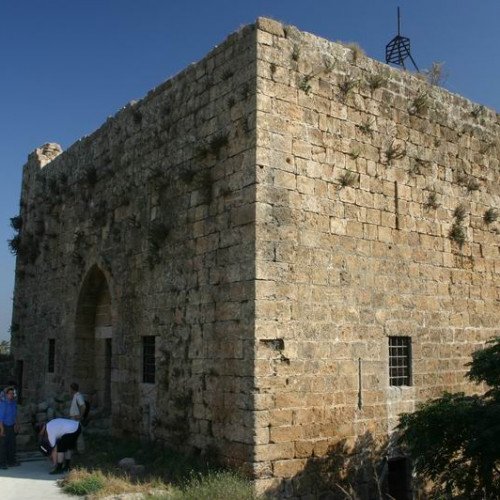
Chastel Rouge, also called Qal’at Yahmur (Arabic: قلعة يحمور, Castle of Yahmur) is a small Crusader stronghold in the North West of Syria that belonged to the County of Tripoli. It is also identified as Castrum Rubrum mentioned in Latin texts. The castle stands in the village of Yahmur, at 12 kilometres' distance from Tartus and 10 kilometres from Safita, where the Tortosa and Chastel Blanc Crusader castles can be found. Little is known about the capture and early development of the place by the Crusaders. This is because it was a castle of secondary importance, and also to some doubts in identifying the castle in medieval sources. However, it was granted by Tancred to Pons, Count of Tripoli in 1112. Later on, the stronghold seems to be in the hands of a Frankish family, the Montolieu, vassals of the Counts of Tripoli. Thus, it was part of the network of castles defending the County, for example Crac des Chevaliers, Chastel Blanc and Areimeh. In 1177/78, Raymond III transferred the stronghold to the Hospitallers, and the Montolieus were given 400 bezants as compensation. In 1188, Saladin attacked the stronghold and destroyed it. The Crusaders could most probably retrieve it and keep it until they lost the County one century later, during the reign of Mamluk sultan Qalawun in 1289. The village of Yahmur is located in the coastal plain between Tartus and Tripoli. Consequently, Chastel Rouge did not possess natural defences, as many other castles did. The stronghold consists in a two-floor donjon, 16 metres long and 14 metres wide, enclosed in rectangular outer walls of 42 metres' length and 37 metres' width, with towers on the north-western and south-eastern angles. The first floor was divided in two storeys by a wooden floor that does not exist any more. Upper floors can be reached through stairs running along the walls inside and outside the donjon. The construction cannot be dated with exactitude, however two main phases can be recognised: the first phase dates from the beginning of the 12th century and includes the outer walls, while the donjon was built at the beginning of the 13th century. Excavations in the stronghold also found ruins date back to the Phoenician era, in addition to inscriptions from the Greco-Roman period.