Castles of "South Africa" FORT AMIEL MUSEUM vs HANGLIP

FORT AMIEL MUSEUM
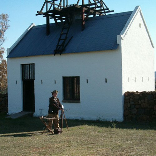
Fort Amiel Museum is in Newcastle KwaZulu-Natal, South Africa. Fort Amiel was constructed in 1876 by Major Charles Frederick Amiel and soldiers of the 80th Staffordshire Volunteers. It was built as a fort and "look-out post", for the British during the run up to the annexation of the former Transvaal and the Zulu War, although it really never served that purpose. During the First Boer War it was used as a garrison for the King's Own Royal Regiment (Lancaster). Fort Amiel served as a commissariat depot, transit camp and hospital. Many wounded soldiers were taken there, to recover from their wounds. The fort is positioned on a knoll overlooking the original wagon drift across the Ncandu River. It has majestic views of the Drakensberg mountain range and the town of Newcastle. Major Charles Frederick Amiel was born on 2 August 1822, in Hanover Square, London, England. He was christened on 2 August 1822 in St Peter, Chertsey, Surrey, England. Major Amiel died on 10 September 1885 at London, England. He was buried at St Peter, Westminster, London. Amiel never married. The fort and surroundings, including a graveyard below the knoll fell into disuse for many years. In 1979 the site was declared a National Monument and restoration work began after the discovery of the original plans for the fort were discovered during this period in a London Museum. The restoration work was undertaken by the visionary Newcastle Town Council and in conjunction with the Natal Museum Services. Today, Fort Amiel houses an historic/cultural museum, featuring military displays of the two Anglo-Boer Wars. There is a wonderful cookhouse re-construction, showing a typical British Army Base found in the 1880s. An addition to the fort and museum is a Zulu umuzi (hut) with a detailed interior.
Statistics for this Xoptio

HANGLIP
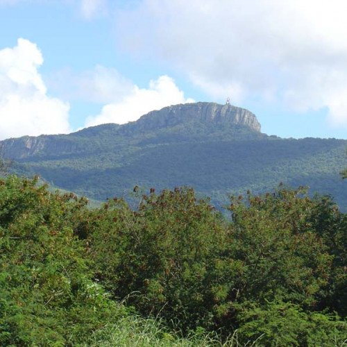
Hanglip (Afrikaans for hanging lip, Venda: Songozwi'),8 thavha ya VhaDzanani is a prominent mountain peak near Louis Trichardt, South Africa. It is situated in the Vhembe District of Limpopo in the central Soutpansberg range. The peak with radar station, at 1,719 meters a.s.l., forms a conspicuous landmark visible from the town and the N1 national road. Hanglip mountain is situated in the 354 hectare Hanglip Forest Reserve within the Hanglip State Forest. The state forest contains commercial pine plantations, protected natural forest and bushveld. The pine plantations are harvested in 30 to 40 year cycles for construction wood. Geologically the mountain consists of tilted layers of the Karoo succession including glacial till deposits. Red quartzite deposits and grey andesite lava intrusions are also present. Songozwi was the VhaVenda area, under the VhaDzanani clan and their Chiefs, and later joined by the Mphephu/Ramabulana clan. The VhaDzanani clan have their sacred site in mount Songozwi, while the Ramabulana clan bury their chiefs there at a place or hill called Luatame. The whole region was Dzanani (named after the VhaDzanani) until 1946. This is because Songozwi was made a white-only area after 1913. Vhavenda were then evicted from this fertile area, the last group of Vhavenda left the area around the 60s. Eviction started around Schoemansdal after the 1898/9 Vhavenda - boer War. The boer were led by general Piet Joubert. As safeguard against further attacks, Fort Botha was established under Hanglip some kilometers southwest of Mphephu's kraal. The ruins of the fort are currently off limits, being situated near graves of the Singos and the sacred site of vhaDzanani on the other side. The town of Trichardtsdorp was established after the conflict. The Hanglip Forest Reserve is a protected area in the zone of the mountain. Hikers can arrange to overnight in the Hanglip trail hut east of the peak, and motorists can visit a picnic site against its southern slope.